Hurricane Milton is forecast to make landfall overnight Wednesday along Florida’s Gulf Coast — though precisely when and where it will strike still remains uncertain.
Current predictions suggest it may land just south of Tampa Bay, an outcome which would spare the low-lying metropolis the worst flooding.
But forecasters are cautioning it is still too early to determine the final landfall, as some models show Tampa Bay could still be in Milton’s sights.
And the storm is still growing. As of the National Hurricane Center’s 2 p.m. update on Wednesday, Milton had swelled by 75 miles in just three hours to reach 250 miles across.
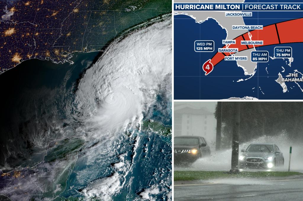
The storm remains a Category 4, with sustained winds around 130 mph.
It also nearly doubled in speed Wednesday, moving northeast at 17 mph towards Florida’s Gulf coast, Fox Weather meteorologist Stephanie van Oppen told The Post.
You can track the path of Hurricane Milton live here.
Key: MH — major hurricane; HU — hurricane; TS – tropical storm; STS — subtropical storm
“Right now there’s still a lot of uncertainty of where exactly it might make landfall, but most models are looking like it might be just south of Tampa, near Bradenton, maybe Sarasota area, which would bring the worst storm surge to just south of those regions,” van Oppen said.
“In that scenario, Tampa might not see the worst storm surge, but they would definitely see very strong winds from the eyewall of the storm as it moves onshore overnight,” she added.
Van Oppen added that it is still “very possible” Milton will move north in the next 12 hours before it makes landfall.
Such a path would put the 3.3 million Tampa Bay area residents at significant risk, as the storm surge could bring flood waters up to 15 feet deep crashing onto city streets.

An updated projection of Hurricane Milton’s projected path provided to The Post on Wednesday afternoon. FOX Weather

The latest cone image of Milton NOAA

A satellite image of Hurricane Milton on Wednesday afternoon as it approaches the western coast of Florida. NOAA / SWNS

The forecast track for Hurricane Milton. Fox Weather
“Right now, I would say Sarasota is the most likely point that we might see landfall,” van Oppen said.
“But that should not put anyone in Tampa at ease, because they’re still going to see very heavy rain and damaging winds, even if they are spared from the most extreme storm surge.”
Follow the latest from The Post on Hurricane Milton: Hurricane Milton live news updates: Historic storm to wallop Florida Hurricane Milton tracker: Live updates on the storm’s path through Florida If Hurricane Milton wasn’t bad enough, monster storm is spawning tornado supercells to wreak havoc on Florida Hurricane Milton expected to be so powerful, it could forever change Florida’s coastline Tampa mayor warns Floridians who plan to ride out Hurricane Milton at home: ‘That’s a coffin you’re in’
Current projections show the storm reaching land sometime between midnight and 2 a.m., van Oppen said.
The most recent spaghetti models, or long-range forecast models showcasing multiple possible outcomes, show it could hit anywhere on a 60-mile stretch along the coastline between Tampa and North Port — which is north of Fort Myers.

Cars evacuating Titusville, Florida in the rain as Milton approaches. TIM SHORTT / FLORIDA TODAY / USA TODAY NETWORK via Imagn Images
Van Oppen said Fox Weather forecasters had “medium confidence” in the current predictions — meaning Milton’s path may dramatically shift over the next 12 hours.
While Milton is projected to land as a slightly weaker major hurricane, meteorologists predict it still may be one of the most destructive storms to date on the Gulf Coast, bringing flash floods and devastating winds along with the dangerous storm surges in some regions.
“Since storm surge forecasts are highly sensitive to the exact track, this means that… storm surge heights across the Tampa Bay region and south may vary widely,” the National Hurricane Center warned on Wednesday.
“However, the risk of devastating storm surge still exists across much of the west-central and southwest coast of Florida.”